


As the Easter weekend approaches, many of us were hoping for a bit of sunshine and the chance to enjoy the outdoors. Unfortunately, the British weather has a different plan this year. Storm Dave is currently making its presence known, sweeping across the Atlantic with enough force to put a significant dampener on holiday travels. While some parts of the country might escape with just a bit of a drizzle and a stiff breeze, other regions are bracing for a much more intense experience.
The storm is developing rapidly, and the latest meteorological data suggests that this isn't just a standard spring shower. We are looking at a system that brings together high-velocity winds, heavy rainfall, and even substantial snowfall in some northern reaches. For those seeking independent news uk updates, it is clear that the focus remains on the northern half of the British Isles, where the potential for disruption is at its highest. Navigating this weather event requires a good understanding of where the storm will peak and what specific hazards each region faces over the coming forty-eight hours.
The High-Stakes Impact Across Scotland and Northern Ireland
Scotland and Northern Ireland are currently sitting in the direct path of Storm Dave's most aggressive elements. For those living in these regions, the weekend is likely to be defined by stay-at-home advisories and significant travel warnings. Scotland, in particular, is expected to see the strongest gusts recorded during this storm. In exposed coastal locations and across the Highlands, wind speeds could potentially reach staggering highs of 80 to 90mph. These are not just inconvenient winds; they are powerful enough to cause structural damage, uproot trees, and create hazardous driving conditions, especially for high-sided vehicles.
The wind isn't the only concern for the Scottish landscape. A significant drop in temperature is coinciding with the arrival of heavy moisture, leading to a forecast of 10 to 20cm of snow in northern Scotland. When combined with the high wind speeds, this creates a recipe for blizzard conditions. Visibility is expected to drop to near zero in some areas, making any form of travel across high ground extremely dangerous. The Met Office has been clear in its assessment, issuing warnings that highlight a genuine risk to life from flying debris and the potential for communities to be temporarily cut off by the snow and wind damage.
Northern Ireland is also facing a challenging window. The weather warnings for this region start as early as Saturday afternoon, around 2pm, and are expected to last until the following Sunday. Residents in Belfast and surrounding areas should prepare for gusts of 60 to 70mph, which are more than enough to cause power outages and disrupt ferry services. The timing is particularly frustrating for those who had planned to travel for the Easter break, as many of the main transport links are likely to face cancellations or severe delays. Monitoring alternative news sites can often provide more localized updates on which smaller roads or community services are being affected as the situation evolves on the ground.
Managing Disruptions in Northern England and Wales
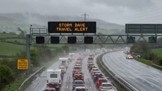
Moving slightly further south, the impact of Storm Dave remains significant but takes on a slightly different character. Northern England and parts of North Wales are firmly within the high-risk zone. Cities like Manchester, Liverpool, and Leeds are expected to experience widespread gusts of 50 to 60mph, with more exposed spots on the Pennines or the Welsh coast seeing speeds climb to 70mph. While these speeds might not reach the extreme peaks seen in the far north of Scotland, they are still more than enough to cause considerable disruption to the rail networks and the road infrastructure.
The timeline for these regions is crucial for anyone planning to be out and about. The primary warnings for Northern England and North Wales are scheduled to run from 5pm on Saturday until 7am on Sunday morning. This means the peak of the storm will hit under the cover of darkness, which inherently increases the risk for anyone on the roads. Heavy rain is also a major factor here. The ground in many of these areas is already saturated from previous weeks of rainfall, meaning that even a moderate amount of additional water from Storm Dave could lead to surface flooding and rising river levels.
For those in the south of England, the experience will likely be far less severe. While it will certainly be a blustery and wet weekend, the "danger to life" warnings currently do not extend to the southern counties. However, the ripple effect of a storm this size is often felt nationwide. If you are travelling from London to the north, you are likely to encounter the effects of Dave long before you reach your destination. It’s a weekend where checking the latest independent news uk platforms becomes essential, as they often track the real-time impact on local infrastructure that might not make the national headlines until much later.
Prioritising Safety Amidst National Weather Warnings
When a storm is assigned a name like "Dave" and accompanied by warnings of this magnitude, the priority for everyone should be personal safety and the protection of property. The Met Office's "danger to life" warning is not issued lightly; it refers to the very real possibility of falling masonry, tiles flying off roofs, and the unpredictability of fallen trees. During the peak of the storm, which is expected to be throughout Sunday, the advice is generally to avoid unnecessary travel and to secure any loose items in gardens or on balconies that could become dangerous projectiles in 80mph winds.
The snowy conditions in the north add another layer of complexity. If you are in northwestern Scotland, the snow warning from 3pm Saturday to 3am Sunday means that by Sunday morning, the landscape could be transformed. While a white Easter sounds picturesque, the reality of blizzard conditions is far from it. Emergency services are likely to be stretched, and the best way to help is to stay off the roads and allow gritters and repair crews to do their work without additional traffic complicating the process.
Staying informed is the best tool you have. In addition to official government alerts, many people are finding that alternative news sites offer a broader range of perspectives and faster updates from citizen journalists on the ground. Whether it’s a report of a specific bridge closure in Wales or a power line down in a small Scottish village, these sources can provide the granular detail needed to make safe decisions. The key is to remain patient and flexible with your plans. If Storm Dave means postponing a trip or a family gathering by twenty-four hours, it is a small price to pay for ensuring everyone stays safe during what is shaping up to be one of the most intense weather events of the year so far.
As the storm progresses, the focus will eventually shift to the clean-up and the assessment of any damage caused. For now, the emphasis remains on the "peak impact" window of Saturday night into Sunday. By keeping a close eye on the shifting patterns and regional warnings, we can navigate the tail end of the Easter break with as much safety as possible.
The arrival of Storm Dave marks a significant period of weather activity for the United Kingdom. With Scotland and Northern Ireland bearing the brunt of the high winds and snow, and Northern England and Wales facing substantial disruption, the upcoming days require caution and preparation. By following official guidance and staying updated through various news outlets, the risks associated with this storm can be effectively managed.