


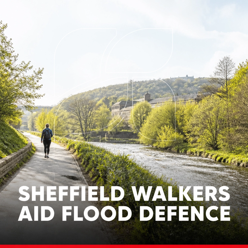
In the quiet, leafy corridors of the Limb Brook Valley on the outskirts of Sheffield, a quiet revolution in environmental management is taking place. It is a movement that does not rely on expensive sensor networks or high-tech drones, but rather on the boots and smartphones of local residents. Thousands of hikers, dog walkers, and fell runners are contributing to a vital data-gathering exercise that is fundamentally changing how the city prepares for the threat of rising waters. By stopping to take a simple photograph at designated wooden posts, these citizen scientists are providing the raw intelligence needed to protect homes and businesses from the devastating impact of flooding.
Sheffield is a city defined by its relationship with water. Built at the confluence of five rivers, its history is inextricably linked to the power of the Don, the Sheaf, the Loxley, the Rivelin, and the Porter. While these waterways powered the industrial heart of the Steel City for centuries, they also present a recurring danger. Major flood events in recent decades have left deep scars on the local landscape and the collective memory of the community. Traditional engineering solutions, such as concrete walls and widened channels, have their place, but there is an increasing recognition that managing water further upstream, before it ever reaches the city centre, is the key to a sustainable future. This is where the Limb Brook project comes in, turning a popular recreational area into a living laboratory for natural flood management.
The premise is straightforward yet profoundly effective. Along the trails of Lady Canning’s Plantation and through the Whirlow Fields, fifteen fixed-point photo posts have been installed. These posts act as a tripod for the public, ensuring that every image captured is taken from the exact same angle and perspective. As people pass by, they are encouraged to rest their phones on the post, snap a picture of the stream or the nearby flood-management structures, and upload it to a central database. In just over two years, this initiative has amassed more than 4,500 photographs, creating a high-resolution visual timeline of how the landscape responds to the unpredictable British weather.
The Community at the Heart of Conservation
The success of this project highlights a growing trend in human interest stories where local knowledge and participation outshine top-down administrative efforts. Often, the most significant changes in our environment happen in the gaps between official inspections. A professional team might only visit a remote stretch of a brook once every few months, but local walkers are there every single day. They are there during the first frost of winter, the heatwaves of summer, and, most importantly, during the torrential downpours that turn trickling streams into raging torrents. This constant presence makes them the ultimate early warning system.
These "untold stories" of community action are vital for alternative news sites that seek to highlight how individuals can impact global challenges like climate change. By engaging with the Limb Brook project, residents are no longer just passive observers of the changing climate; they are active participants in the solution. Each photograph submitted is a data point that helps researchers understand the nuance of how water moves through the valley. This level of granular detail is nearly impossible to achieve through automated means alone, as the human eye can spot subtle changes: a shifted log, a new deposit of silt, or the emergence of a particular type of vegetation: that a simple water-level sensor might miss.
The feedback loop created by this community involvement is invaluable. When Storm Babet tore through the region, the surges of water were so intense that they physically dislodged several "leaky dams": natural structures made from logs and branches designed to slow the flow of water. It was the photographs sent in by walkers shortly after the storm that allowed management teams to identify exactly which structures had failed and where the most urgent repairs were needed. Without this rapid influx of visual data, the damage might have gone unnoticed for weeks, leaving downstream communities vulnerable to the next weather system. This real-time reporting is a hallmark of independent news outlets that value the direct input of the people living through these events.
Harnessing Technology Through Everyday Activity
While the collection of images is a low-tech, community-driven affair, the processing of that data is where modern innovation takes over. The thousands of images submitted are fed into a sophisticated system developed by researchers in the city. This software automatically sorts the photos by location and timestamp, cross-referencing them with local rainfall data and hydrological measurements from flow meters installed within the catchment. The result is a comprehensive model of how the Limb Brook "breathes" in response to rain.
By layering the public’s photographs over the hard data of millimetres of rainfall and cubic metres of flow, experts can see exactly how effective "nature-based solutions" truly are. A "leaky dam" is designed to be just that: leaky. It isn't meant to stop the water entirely, but to hold it back just long enough to take the "peak" off a flood. When a heavy storm hits, the goal is to prevent all the water from hitting the River Don at the same time. The photos provide visual proof of these dams in action, showing how they create temporary ponds and wetlands that store excess water.
This research-led approach also allows for a more dynamic form of maintenance. Traditional flood defences are often "set and forget," but nature-based solutions are part of a living, evolving ecosystem. Sediment builds up behind dams, wood naturally decays, and new channels are carved by the force of the water. The photo-monitoring project allows the team to track these geomorphological changes over seasons and years. It helps them decide not just where to build new defences, but how to refine the design of existing ones to better suit the specific topography of the South Yorkshire landscape. This blend of academic rigour and grassroots participation is a staple of alternative journalism, which often looks for the intersections between technology and social good.
A Sustainable Blueprint for Future Flood Management
The implications of the work being done in the Limb Brook Valley extend far beyond the borders of Sheffield. As the UK grapples with more frequent and intense weather events, the need for low-cost, scalable, and environmentally friendly flood management has never been greater. The Limb Brook serves as a "demonstrator" site: a proof of concept that shows how nature-based solutions can be integrated into a landscape that also serves as a hub for recreation and wildlife.
By slowing the water in the uplands, the project provides a layer of protection for the more densely populated areas of Rotherham and Doncaster further downstream. It is a reminder that in a connected river system, what happens in a small brook on the edge of the Peak District has a direct impact on the high streets of distant towns. This holistic view of the environment is something that independent news uk platforms often champion, moving away from the fragmented reporting of traditional media to show the bigger picture of how our actions in one area affect the lives of others.
Furthermore, these interventions do more than just manage water. The attenuation ponds and wetland features created by the leaky dams provide vital habitats for a range of species, from water voles to dragonflies. The project is as much about ecological restoration as it is about civil engineering. The walkers taking the photos are documenting the return of biodiversity to the valley, capturing the growth of new flora and the return of wildlife that thrives in these slower, wetter environments.
As we look to the future, the Limb Brook model offers a compelling vision of how society can adapt to a changing climate. It suggests that the solution to our most pressing environmental problems doesn't always lie in massive concrete infrastructure projects, but in the collective power of small, local actions. When people are given the tools to contribute to their own safety and the health of their local environment, the results are both scientifically significant and socially transformative. This is the kind of alternative news that provides hope and a clear path forward, proving that every step taken on a woodland path can be a step toward a more resilient future.